I regularly look at a painting on my wall of a very tranquil watercolour of a canal scene with which I was once very familiar. The centre of the picture is a closed canal lock gate, with its walk way across to the lock keepers cottage. To the left is the towpath with trees away from the waterside and the reed lined water is still, with barely a ripple on the fully closed lock, reflecting the cottage and trees. Looking at the painting is very peaceful.
As a young schoolboy we lived about a mile from the canal, The Kennet and Avon, in Wiltshire, frequently referred to as “The Cut”, because years before it had been cut from the local land.
Sunday, being a day of rest, after bell ringing and choir singing and lunch, my father often proposed a walk if the weather was fine. One of the favourite walks was along the road (not then busy) to the bridge over the canal, down a pathway to the canal tow path, which we then climbed in parallel with the canal. Father would point out wildlife in the water, around the reeds near the bank, moorhens, coots, dabchicks (grebe) and occasionally a heron (or crane). Possibly a duck with its family following in line astern. Occasionally a solitary swan proceeded majestically in the middle of the water. At this time the canal was derelict and the only craft was a motorised barge for maintenance. As this part of the canal contained the famous “staircase” flight of 29 locks at Caen Hill, taking the water up hill, there were 16 “Pounds” or reservoirs at intervals used when locks were opened. The heavy wooden lock gates were operated manually to let water out if a boat was descending or closed to raise the level if ascending. Progress was slow for the barges! When we reached the top of the flight we left the canal side for the road, to another path called Gooseberry Lane, onto Dunkirk Hill and eventually back to our village. I saw no fish, but some said they had a catch so I tried with a hazel rod and bent pin, but went home empty handed. The winters were harder then and the water became sufficiently frozen for skating, or small boys to slide upon. A few years later I discovered the young lady to become my wife lived on the other side of the canal, so it had separated us for some time!
Some years since the canal was rescued and renovated, to be re-opened by the Queen in 1990, so that it now is full of holiday traffic in motorised craft. When it was a working canal, the barges were towed by horses, from the tow path. The lock keepers cottage became a café and ice cream purveyor. In Devon at Tiverton a horse drawn barge provides quiet, picturesque trips for tourists, to give perhaps a flavour of life in bygone days. This is what is left of the Grand Western Canal started by John Rennie in 1810 the year he completed the Kennet and Avon.
Dorset has no canal but once there was a plan to build a Somerset and Dorset Canal with the intention of linking the Bristol and English Channels, between Bristol and Poole. This was first discussed in Wincanton, Somerset in January 1793 and would have saved the sea voyage around Cornwall. It was proposed that the canal would enable transport of coal from the Somerset coalfields to Dorset, also stone and lime and in return timber, slate and wool from Dorset. Another possible cargo was clay from Purbeck to the potteries in Staffordshire. A recent book by Roger Guttridge “Dorset Curious and Surprising” states the original route was from Bath to Frome, with a branch to the Mendip collieries. Then via Wincanton and Henstridge in Somerset and Stalbridge, Sturminster Newton, King’s Stag Bridge, Mappowder, Ansty, Puddletown and Wareham to Poole Harbour in Dorset. However a meeting in Blandford proposed that the route would be better from Sturminster Newton via Blandford to Poole, instead of Wareham. An additional proposal was a 9 mile extension to a junction with the Kennet and Avon Canal I described near Bradford on Avon in Wiltshire which would thus eventually provide access to London.
Unfortunately some landowners in East Dorset and in particular Lord Rivers objected to the proposal. Lord Rivers would only agree if “the canal did not proceed beyond some point betwixt Sturminster and Blandford, otherwise withholding his consent”. As a result it was decided in 1796 to abandon the southern section, terminating at Gain’s Cross, south of Shillingstone. This would reduce the length of the canal to 48 miles and there would be no route to Poole and the English Channel which had been a considerable selling point. An Act of Parliament had been passed in March 1796 which authorised the company to draw water up to 2,000 yards from the canal and to raise £150,000 in shares. Progress was slow through rocky terrain and the money subscribed was insufficient. Construction ceased in 1803 with only 8 miles completed starting at Cote in Stratton parish for the Mendip colleries branch in Somerset.
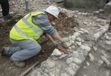
I have found a reference to a report by a Joseph Priestly in 1831 from which it appears that locks were to be avoided by the use of a boat lift. A portion of the Nettle Bridge branch was excavated and on a fall of 21 feet at Mells near Frome one of Fussells balance locks was tried with vessels of 10 tons burthen in September and October. Remains of aqueducts, bridges, embankments and lengths of canal can still be found in the western section in Somerset. There are photographs, one of a bridge over probably a farm track with shrubbery growing over the top, another of an excavation site with large stones and possibly remains of an aqueduct. Several river crossings would have been required.
It appears that no work was commenced in Dorset so there is nothing for us to see of the enterprise unfortunately. Had it been completed it may have improved trade and industry here and now either have been an attractive waterway for pleasure craft or a tranquil walk as I remember from my earlier days. Thankfully we have many other walks.


